“Africa’s second-highest mountain: routes, gates, fees, the best time to go, and how to get there by 4×4 or transfer from Nairobi”
Mount Kenya is the highest mountain in Kenya and the second highest in Africa, a worn, glaciated volcano that rises from the central highlands almost exactly on the Equator. It is a UNESCO World Heritage Site, a place of forest, moorland, glacial lakes, and jagged twin peaks, and one of the continent’s most rewarding mountains to trek.
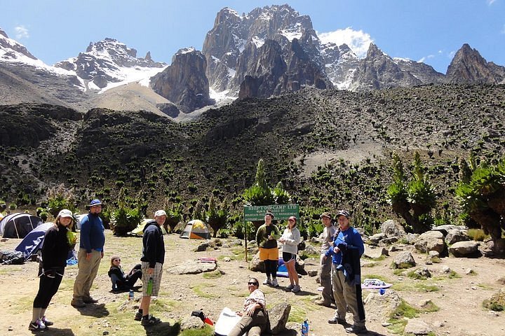
You can reach its lower slopes on a day trip from Nairobi or spend several days walking to the summit viewpoint at Point Lenana.
| What you want to know | The answer |
| Height | Batian 5,199 m (highest), Nelion 5,188 m, Point Lenana 4,985 m (the trekkers’ summit) |
| Status | UNESCO World Heritage Site (inscribed 1997), managed by the Kenya Wildlife Service (KWS) |
| Where it is | Central Kenya, across the Nyeri, Kirinyaga, Meru, Embu, and Tharaka-Nithi areas |
| Distance from Nairobi | About 190 to 200 km to the main gates, roughly 3 to 4 hours by road to Nanyuki |
| Main gates | Naro Moru (west), Sirimon (northwest), and Chogoria (east), plus smaller gates |
| Can I climb it? | Point Lenana is a trek for fit, well-prepared walkers. Batian and Nelion need technical rock-climbing skills. |
| How long? | Typically 4 to 6 days for Point Lenana. KWS advises at least 3 nights on the way up to acclimatize. |
| Best time | The dry seasons: roughly January to March and late June to October |
| Getting there | Self-drive 4×4, driver-guide, or a chauffeur-driven transfer from Nairobi to Nanyuki and Mount Kenya |
| Not a climber? | Drive to the gates, enjoy the forest and moorland, and combine it with Laikipia, Lewa and Samburu |
Why visit Mount Kenya?
Kenya takes its name from this mountain. For the Kikuyu people who live on its southern and western slopes, it is the throne of Ngai, their god, and its snow-capped summit is a landmark visible from far across the plains on a clear morning.
It is also a remarkable natural place. The mountain is an extinct volcano, eroded over time into jagged peaks and deep glacial valleys. As you climb, the landscape changes in layers: farmland gives way to thick montane forest, then bamboo, then open moorland dotted with giant lobelias and groundsels, and finally rock, scree, and ice. Hyraxes are common near the high camps, and the forests shelter elephants, buffalo, and the rare mountain bongo.
The three summits
| Peak | Height | Who it is for |
| Batian | 5,199 m | The highest summit. Technical rock climbing only, usually a very long summit day. |
| Nelion | 5,188 m | The slightly lower twin. Also technical, with multi-pitch climbing. |
| Point Lenana | 4,985 m | The third summit and the one most visitors reach. Non-technical, but high, cold, and demanding. |
Point Lenana is widely regarded as one of the most accessible high-altitude summits in Africa, and it rewards climbers with a sunrise above a sea of cloud. Even so, it stands at nearly 5,000 meters, so treat it with respect.
How to get to Mount Kenya
From Nairobi, the usual route is north on the Thika Superhighway towards Nanyuki, which is the largest service town on the north-western flank. Nanyuki is about 200 km from Nairobi, and the drive takes roughly 3 to 4 hours depending on traffic. From Nanyuki you can reach the Sirimon gate or continue towards Naro Moru and the Naro Moru gate on the Nyeri to Nanyuki road. The eastern Chogoria gate is reached via the Embu to Meru road.

| Gate | Where | Distance from Nairobi | Why choose it |
| Naro Moru | Western side, near Naro Moru town on the Nyeri to Nanyuki road | About 188 km | The shortest and most direct route to Point Lenana, with KWS headquarters for the mountain and a rescue base |
| Sirimon | North-western side, off the Nanyuki to Meru road | About 200 km | A gradual ascent, good acclimatisation, and the best chance of wildlife on the way up |
| Chogoria | Eastern side, near Chogoria town | Further by road; confirm the distance. | Often described as the most scenic route, with valleys and glacial lakes |
| Other gates | Kamweti, Kihari, and Mawingu | Varies | Less used. Some are used for routes that need KWS approval in advance. |
By air: Nanyuki has an airstrip, and flights from Wilson Airport take about an hour.
If you are collecting your vehicle on arrival, see our Airport Car Rental in Nairobi page for the meet-and-greet handover at JKIA and Wilson Airport.
Self-drive, driver guide, or transfer: the best way to reach Mount Kenya
The main roads to Nanyuki are tarmac and suitable for almost any vehicle. The difference appears when you leave the highway. The road around the mountain is paved, but the approach roads to the gates and the tracks inside the park can be rough, and some trails need a 4×4. How you travel depends on what you plan to do.
| Your plan | Best option | Why |
| A scenic day or weekend around Mount Kenya, Nanyuki and Laikipia | Self-drive Land Cruiser LX or V8, or Nissan X-Trail for tarmac only | Freedom to stop with a capable vehicle for gate and park roads. |
| Driving into the park to the gates, bands, or the lower tracks | Land Cruiser Hardtop, LX, or V8 | Ground clearance and four-wheel drive for rough sections. |
| A multi-day trek, with a guide and porters booked by a trekking operator | Chauffeur-driven transfer from Nairobi to the gate | You do not need to park a vehicle for days or worry about the return drive. A Voxy, Noah, or shuttle suits the road. |
| A traverse, going up one route and down another (for example, Sirimon up and Chogoria down) | Transfer, or one-way rental with a planned pickup | Your start and finish gates are far apart. A driver can meet you at the exit. |
| A family or group wanting comfort and no navigation | Extended Land Cruiser with a driver-guide, or a Voxy, Noah, or shuttle transfer | The vehicle and driver stay with you, and the driver knows the roads. |
We offer chauffeur-driven transfers from Nairobi and from the airport to Nanyuki and Mount Kenya, using taxis, Toyota Voxy, Toyota Noahs, and shuttles, as well as self-drive Land Cruisers and the Nissan X-Trail. See our Nairobi airport transfers for more.
Trekking and your vehicle
If you self-drive to a gate and then trek for several days, think about where the vehicle will wait. Leaving it at a gate for the length of your trek is common, but confirm parking and security arrangements with your trekking operator and the KWS gate in advance. If you plan to finish at a different gate from the one you started at, talk to us before you book, so we can arrange the right transfer or a one-way rental.
Climbing routes to Point Lenana
About 90 percent of trekkers use three main routes: Naro Moru, Sirimon, and Chogoria. Many combine two of them, going up one way and down another.
| Route | Character | Key camps and features | Best for |
| Naro Moru | The fastest and most direct. Steep in places, with the famous Vertical Bog section. | Met Station, Mackinder’s Camp, and the Austrian Hut below Point Lenana. Rock hyraxes near Mackinder’s. | Travellers with limited time |
| Sirimon | A gradual, scenic ascent and the best route for acclimatization and wildlife. | Old Moses Camp, Liki North Camp, and Shipton’s Camp. KWS bands at the gate. | First-time Mount Kenya trekkers |
| Chogoria | Often called the most beautiful. Long valleys, tarns, and dramatic scenery. | Gorges Valley, Lake Michaelson, and Lake Ellis areas, and the route down through forest. | Scenic descent, or trekkers with more time |
| Burguret, Kamweti, and others | Wilder, less frequented routes. | Wild camping. Route-finding is harder, and KWS often requires rangers for wildlife safety. | Experienced hikers with a specialist operator |
How long does it take?
Most itineraries take 4 to 6 days to reach Point Lenana and return, depending on the route and how you acclimatize. KWS recommends spending at least three nights on the way up. A common pattern is to ascend by Sirimon, summit at dawn from a high camp, and descend by Naro Moru or Chogoria. The summit climb itself usually starts in the small hours so you can reach the top for sunrise.
Do I need a guide?
For the main routes to higher camps, plan to go with a licensed guide and porters. Guide and porter services, permits, huts, and meals are typically arranged by a trekking operator. Some lower-altitude routes can be walked without an official guide, but you must tell the park office your plan and exit gate in advance, and park rules and ranger requirements can change.
Things to do around Mount Kenya (without climbing)
You do not have to climb to enjoy Mount Kenya. The lower slopes and the towns around the base are full of things to do.
| Activity | What to expect |
| Drive to the park gates. | Winding roads through farmland and forest, with views of the peaks on clear mornings. |
| Forest walks and birdwatching | Montane forests, bamboo, and moorland are home to forest birds and, if you are lucky, monkeys and larger animals. Walk with a guide. |
| Sirimon and Naro Moru day visits | Drive up to the lower slopes, take a short guided walk, and enjoy the moorland scenery. |
| Stay in a KWS banda or forest lodge. | Sleep on the slopes, with cool air, wood fires, and early-morning mountain views. |
| Cross the Equator at Nanyuki | Nanyuki sits on the Equator, a classic photo stop on the way. |
| Combine with a Laikipia safari. | Private conservancies and sanctuaries around Nanyuki offer game drives, rhinos, and more. Check the current options. |
| Fly or drive on to Lewa and Samburu | Mount Kenya sits on a natural route to Isiolo, Lewa and Samburu for a northern safari. |
Best time to visit Mount Kenya
| Period | Conditions | Our advice |
| January to March | One of the two dry windows. Clearer skies and drier trails. | A popular period for Point Lenana. Book ahead. |
| April to May | Long rains. Wet, cloudy and muddy, especially in the lower forest. | Only for experienced trekkers. Allow extra time. |
| Late June to October | The second dry window. Clear mornings and stable weather. | A good time for trekking and for the drive. |
| November and December | Short rains in places, then a drier spell around the festive season. | Weather is changeable, so check forecasts and conditions before you go. |
Mount Kenya is open all year, but the dry seasons make trails easier and views clearer. Weather on the mountain can change quickly at any time of year, so pack for cold, wind and rain regardless of the season.
Park fees, permits and what to carry
Mount Kenya National Park is managed by KWS, and fees are charged per person per day by visitor category. Published figures vary between sources and years, so always check the current KWS schedule before you travel. One recent guide quotes a non-resident adult rate of about USD 52 per day, with extra charges for camping or huts, rescue and technical climbing permits.
- Pay electronically. KWS gates operate on a cashless system. Pre-pay through the government eCitizen and KWS platform where possible, or ask your trekking operator to arrange it.
- Carry original identification. Bring your original passport or national ID. Photocopies and digital copies are often rejected at remote gates.
- Emergency contacts and insurance. Carry emergency contacts, and make sure your travel insurance covers trekking at altitude and mountain rescue.
- Plastic-free zone. KWS parks are single-use plastic free, so bring reusable bottles.
Altitude, weather and safety
Mount Kenya is not a technical walk to Point Lenana, but it is a serious mountain. Altitude, cold and weather catch out people who assume otherwise.
- Climb slowly, build in an extra night if you can, and follow your guide’s pace. KWS recommends at least three nights for the ascent.
- Know the signs of altitude sickness. Headache, nausea, dizziness and unusual tiredness are warnings. Tell your guide at once. If symptoms worsen, descend. Speak to your doctor before you travel about any medication.
- Dress for cold. Temperatures near the summit can fall well below freezing at night, and wind and rain are common even in the dry season.
- Go with a licensed guide. Experienced guides know the weather, the paths and the rescue procedures. The mountain rescue team operates from Naro Moru.
- Respect wildlife. Elephants and buffalo live in the forest belts. Never approach animals, and walk with a ranger or guide where advised.
- Leave no trace. Carry out all rubbish and keep to the paths.
What to pack
| Item | Why it matters |
| Layered clothing, a warm hat and gloves | Mornings and nights near the summit are very cold. |
| Waterproof jacket and trousers | Rain and wind can arrive quickly. |
| Broken-in waterproof boots and trekking poles | Rocky, steep and sometimes muddy ground. |
| Warm sleeping bag rated for freezing nights | Huts and camps are basic and cold. |
| Head torch with spare batteries | The summit climb starts in the dark. |
| Sun protection and sunglasses | Strong UV at altitude, even on cloudy days. |
| Reusable water bottles and snacks | Stay hydrated, and avoid single-use plastic. |
| First-aid kit and personal medication | Remote areas and limited help. |
| Original passport or ID | Needed at KWS gates. |
Where to stay around Mount Kenya
On the mountain
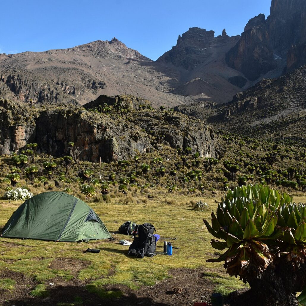
Mountain huts and campsites run along the main routes. Typical camps include Old Moses, Liki North and Shipton’s on the Sirimon side, and Met Station, Mackinder’s and Austrian Hut on the Naro Moru side. KWS also runs bandas at the Sirimon gate and Met Station. Facilities are basic and you should book through your trekking operator or KWS in advance.
In the foothills and the base towns
| Base | Good for |
| Nanyuki | The best-equipped base: shops, restaurants, hotels and the Equator. Ideal for the Sirimon route and for Laikipia. |
| Naro Moru | The closest town to the Naro Moru gate, with lodges and a river-valley setting. |
| Chogoria | A quieter, more authentic base for the eastern route and the Chogoria gate. |
| Mountain and forest lodges | Lodges named in travel guides include Serena Mountain Lodge, Mount Kenya Safari Club, Sirimon Lodge, Castle Forest Lodge and Naro Moru River Lodge. Check each one before booking. |
Sample itineraries
| Trip | Outline | Best vehicle |
| 1-day Mount Kenya escape from Nairobi | Drive to Naro Moru or Nanyuki, visit the lower slopes and gate area, lunch in the foothills, return. | Land Cruiser LX, or a transfer |
| 2-day Nanyuki and Mount Kenya weekend | Day 1: drive to Nanyuki, Equator stop and an afternoon in the foothills. Day 2: Sirimon gate and moorland walk, return to Nairobi. | Land Cruiser LX or V8 |
| 5-day Point Lenana trek | Transfer to the gate, 4 days on the mountain with your trekking operator, transfer back. A traverse such as Sirimon up and Chogoria down needs a planned pickup. | Chauffeur-driven transfer |
| 4-day Mount Kenya and Laikipia safari | Nanyuki as a base, a gentle walk or gate visit, then game drives in the surrounding conservancies. | Land Cruiser V8 or driver-guide |
| 6-day northern loop | Nairobi, Mount Kenya, Isiolo, Lewa or Samburu and back. Ask about a one-way option if you finish in Nairobi by other means. | Land Cruiser V8 |
Frequently asked questions
How high is Mount Kenya?
The highest summit, Batian, is 5,199 metres. Nelion is 5,188 metres and Point Lenana, the trekkers’ summit, is 4,985 metres.
Where is Mount Kenya?
In central Kenya, about 190 to 200 km north of Nairobi, close to the town of Nanyuki and on the Equator.
How far is Mount Kenya from Nairobi?
About 190 to 200 km to the main gates, which is roughly 3 to 4 hours by road to Nanyuki.
Can a beginner climb Mount Kenya?
Point Lenana can be trekked by fit, well-prepared beginners with a guide and proper acclimatisation. Batian and Nelion require technical climbing skills.
How long does it take to climb Mount Kenya?
Typically 4 to 6 days for Point Lenana, depending on the route. KWS advises at least three nights on the way up.
What is the best time to climb Mount Kenya?
The dry seasons, roughly January to March and late June to October.
Which route is best?
Sirimon is gradual and good for acclimatisation, Naro Moru is the shortest and Chogoria is often considered the most scenic. Many people combine two.
Do I need a guide?
For the main high routes, plan on a licensed guide and porters. Check current KWS rules for your route.
How much are the park fees?
Fees are charged per person per day by visitor category. Check the current KWS schedule, because published figures vary.
Can I drive to Mount Kenya myself?
Yes. The roads to Nanyuki are tarmac, and a Land Cruiser is a good choice for gate and park roads. For a long trek, many travellers prefer a transfer.
Do you offer transfers to Nanyuki and Mount Kenya?
Yes. We offer chauffeur-driven transfers from Nairobi and the airport to Nanyuki and Mount Kenya.
Can I leave a rental vehicle at the gate while I trek?
This is common, but you should confirm parking and security with KWS and your trekking operator, and talk to us about your plan before you book.
Can I finish at a different gate?
Yes, many trekkers do. Tell us in advance so we can arrange a transfer or one-way rental.
Can you deliver the vehicle to the airport?
Yes. We offer airport meet and greet at JKIA and Wilson Airport, and delivery and pickup are free on hires of more than 7 days.
The mountain that gave Kenya its name
On a clear dawn, a dark ridge rises above the plains north of Nairobi and then, as the sun reaches it, turns to gold and white. That is Mount Kenya. Closer, the forest closes in, the air turns thin and cold, and the moorland opens into a landscape that feels more like another planet than the savannah below.
Whether you want to stand on Point Lenana at sunrise, walk a quiet forest path or simply drive up to the gate and look, the right vehicle and the right plan make the journey easy.
Tell us your dates, your group and what you want to do. We will recommend the best way to get there, from a self-drive Land Cruiser to a chauffeur-driven transfer. Book your Mount Kenya vehicle or transfer with Car Rental 4×4 today.